Rooted in Richmond
Blossoms & Thorns
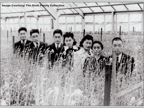
Flora Ninomiya: Imagine the land directly south to you filled with the translucent glass panes of dozens of wooden greenhouses painted in white. It was here that the Sakai nursery started in 1906 with an initial 2.5 acres in a single greenhouse salvaged from Berkeley. The nearby Oishi nursery started shortly after. These greenhouses specialized in cultivating cut flowers for the rapidly growing Flower Mart of San Francisco, where the roses made their way throughout the Bay and beyond. The nursery business was specially suited to the Issei (Japanese-born) Americans and the Nisei (the Japanese American children of immigrants), and it allowed these families to prosper in an era when anti-Asian racism was common. Both the Sakai and Oishi nurseries shut down in 1942 during the World War II relocation of Japanese. Many Japanese internees imprisoned by the U.S. government during the War returned to find their property sold or vandalized, but these nurseries survived without damage, and the families resumed operations when they returned after the war. Until the mid-2000s the nurseries were still owned and operated by the founding families. The City of Richmond acquired them, and has now built affordable housing for seniors on the site, known as Miraflores.

Mobility in the City of Pride and Purpose
You are currently on the Richmond Greenway, which is overlaid on the historic route of the Santa Fe railroad. In 1895, Augustin S. Macdonald visited Point Richmond and conceived the idea of a transcontinental rail terminal and ferry service to provide a direct route from Richmond to San Francisco. Macdonald presented his idea to the Santa Fe Railroad. By 1899 the Santa Fe Railroad established its western terminus in Point Richmond. Earlier, the Southern Pacific-controlled Northern Railway first opened in Richmond in 1878. The Southern Pacific Railroad Depot – Richmond's historic embarkation point – greeted newcomers here starting in the early 1900s. During World War II soldiers kissed loved ones goodbye, while newcomers seeking the economic fruits of wartime arrived after four day cross-country trips. Richmond’s rail travel – like the rest of the country’s – declined after World War II. At the next stop, we’ll look at Pullman Shops, which closed in 1959 and heralded the end of the rail travel era. In the newspaper article reporting on the shop’s closing, it was noted that “The hey-day of railroad travel… was a day when the Pullman Palace Car represented the epitome of gracious traveling.” Though the luxuries of traveling in a Pullman Palace have long passed, Richmondites have taken to a multitude of new forms of transportation. Though biking was a popular activity throughout Richmond’s history, it has undergone a new Renaissance with the completion of the Richmond Greenway and the growth of new groups like Rich City Rides.
Pullman Repair Shops and the Pullman Porters
This section of the Richmond Greenway passes through a swath of land known as “Pullman,” which includes the only remaining building of the Pullman Palace Car Company. In 1908 The Pullman Company came to Richmond to assess the possibilities of a new railcar repair facility. The Pullman Company needed a repair shop to serve the fast-growing population on the west coast. While visiting Richmond, the Pullman group saw enormous potential in the city. Feeling it could be a good choice, since train yards and terminals had been previously established by the Santa Fe, Southern Pacific, and Western Union companies. This and the city's potential to supply inexpensive oil solidified the deal. Pullman set up shop on Carlson Boulevard shortly after and began servicing its cross-country cars there. With the advent of rail car servicing, the porters who worked in the cars would require lodgings, hot meals, and someplace to sleep and socialize. The Pullman Hotel provided this service for the White workers, while Black porters stayed at the International Hotel just a block away. The street-level floor of the International Hotel boasted a large area suitable for gathering and entertainment. It’s probable, though not verifiable by the established historical record, that the International Hotel (which frequently lodged Black train porters and had connections to co-founder C.L. Dellums) was where porters discussed the possibilities of forming the first-ever Black labor union: The Brotherhood of Sleeping Car Porters. Founded in 1925, The BSCP was the first labor group with African American leadership to obtain a charter with the American Federation of Labor. Ultimately, the BSCP gathered a membership of 18,000 passenger railway workers across Canada, Mexico, and the United States. In Richmond, the International Hotel became a Pullman porter gathering spot and, by the second world war, had reportedly played host to the likes of Cab Calloway and Billie Holiday, much to the delight of the porters.
Public Art in the Pullman Neighborhood
Immediately to your left, facing south, is the “Essential Workers of the Pullman Neighborhood” mural, which was completed by a team of Richmond artists, including Rebeca Garcia-Gonzalez, Ramonita Gonzalez, Julianne Wallace Sterling, Caleb Turner, Lorena Plazola and the Groundwork Richmond Green Team. Rebeca Gonzalez is interviewed later on this tour at the stop for Unity Park. The Essential Workers mural was completed at the height of the COVID-19 pandemic in mid-2020, when the community felt it important to highlight images of positive contributions that the city’s essential workers in Richmond made for the greater good of the city during the global pandemic. Throughout the neighborhoods of Richmond, you will find murals tucked into parks and paths providing a home to an array of public art projects. These artistic havens have been adopted, cultivated, and curated by individuals and groups who hope they will connect the communities and brighten the area. Often they are a multi-cultural mosaic, reflecting the heritage of those who live in the neighborhood and the many who risked everything to bring their families to Richmond with the dream of new beginnings. A few blocks west of Pullman Park, you will find Unity Park, which welcomes you with more vibrant designs reflecting the area’s culture. Beautifully rendered, the faces of the neighborhood are friendly and nestled among depictions of local flora and fauna. Meanwhile, over on the Greenway, more art can be found on 2nd through 23rd Streets along Ohio Avenue. The cultivation and creation of art didn’t happen alone. Several groups and community leaders made it happen with the hope of improving the settings and public spaces, a group effort as well as a labor of love.
"Hate is Too Great a Burden" - Social Justice in Richmond
Look north on the road toward the Civic Center. It was there, on June 8th, 2020 that the Youth Solidarity Project marched with hundreds from the Easter Hill United Methodist Church in the “March for Black Lives.” The struggle for Civil Rights and Social Justice in Richmond has a long history perhaps best exemplified by Martin Luther King, Jr’s first visit to California in 1961 at the Easter Hill United Methodist Church on Cutting Boulevard in Richmond. Though California was a long way from the South, racial segregation and violence against Black and Brown Richmondites was common even before the city’s dramatic wartime growth. Throughout California, African Americans were de facto excluded from housing and employment. Though Black Richmondites were allowed to shop and to go to the movies in downtown Richmond, they could not try on clothing. They were not allowed to be buried in the Whites-only Sunset Cemetery located just outside the city limits. All but one of the 35 childcare centers developed by Kaiser for mothers working in the wartime shipyards was racially segregated. Longtime African American Richmondites remember that during the 1920s, Alvarado Park in the nearby hills of Albany and El Cerrito was among the sites in the hills that held local Ku Klux Klan cross burnings and rallies. In the summer of 1924, the Ku Klux Klan planned a statewide convention in Oakland and secured a 4th of July parade permit. Though Oakland revoked the permit, the parade still went forward as planned - not in Oakland, but rather Richmond - where 3,000 Klan members marched on MacDonald Avenue and concluded with an initiation ceremony in the El Cerrito hills. Following the war and the decline in Richmond’s population, segregation in housing and businesses only increased. In 1947, the Richmond branch of the NAACP organized picketing and a boycott of the Cutting Boulevard Lucky’s grocery market, which refused to hire Black clerks. In 1952, a cross was burned at the home of Wilbur Gary, who had moved into a racially segregated housing area in nearby San Pablo. Dr. King and the late Rev. Anderson of Richmond Easter Hill United Methodist Church were old college friends, and in 1961, Dr. King came to Richmond to meet with Rev. Anderson in an effort to assemble western ministers around the burgeoning Civil Rights movement. Rev. Anderson’s son, Ahmad Anderson says that the two spent time in Richmond strategizing about “what was going to take place in the next five years: the March on Washington and the Selma march,” as well as the Birmingham march.
A Revolutionary Civic Center Reborn
Richmond boomed during World War II, so when peace came again in 1945, the city of “pride and purpose” decided to build a new civic center both to reflect its newfound influence and modernity, and to keep its citizens invested and employed as local war industries began to shut down. Famed Bay Area architect Timothy Pfleuger was commissioned for the design. With a career spanning back to the early 1920s, Pfeluger was best known for stunning Art Deco works like the Pacific Telephone & Telegraph Building and the Castro Theater in San Francisco, and the Paramount Theater in Oakland. The Richmond Civic Center was his last design, completed three years after his 1946 death. It showed his style evolving toward the Modernism of the mid-century and is considered to be International style. The Civic Center was revolutionary for including all of Richmond's city government functions in a single complex of buildings oriented around a gracious public plaza. Sitting on six city blocks, City Hall is the centerpiece, flanked by the Memorial Auditorium and Hall of Justice, while the main library sits to the south. By 2002, the Civic Center was aging and needed a seismic upgrade. The city undertook rehabilitation, rather than demolishing the Modernist gem. The challenging project implemented appropriate preservation approaches and was done to LEED Gold level standards, thus preserving Richmond's symbol of post-war pride for future generations.
A Treasure Rediscovered
Before turning left towards MacDonald Avenue, you’ll see a New Deal-era Post Office. It was at this Post Office that an art treasure was rediscovered and saved: a 1940s mural commissioned by the U.S. Treasury’s Section of Fine Arts. The mural, “Richmond Industrial City,” by Victor Arnautoff, had adorned the wall in the post office’s lobby until 1976 when plans for a renovation necessitated its removal. Packed carefully and stored in the basement, the crate had been long forgotten until 2015 when Melinda McCrary from the Richmond Museum of History reached out to a post office maintenance worker to hunt it down. Ultimately turned over to the Museum, the mural was in need of repair, and funds were raised to restore the piece, which was then sent to the Fine Art Conservation Laboratory near Santa Barbara, California, where the delicate restoration process took place under the watchful eye of Conservation Specialist, Scott Haskins. The mural’s artist Victor Arnautoff, a native of Ukraine (then under the Soviet Union), was commissioned to produce murals for several buildings in San Francisco as part of a New Deal era program. Arnautoff, a former student of Mexican Post-Impressionism muralist Diego Rivera, traveled to Richmond to get a feel for the city and its people before starting his project. The final mural depiction is that of Richmond townsfolk and Standard Oil workers set against a backdrop of the refinery and hillside tanks. Restored and shipped back to Richmond, the mural is now permanently housed at the Richmond Museum of History thanks to the valiant efforts of Melinda McCrary and the conservation team.
New Life in Old Buildings
Across the street, is the historic Winters Building, which is on the Richmond Register of Historic Places. In the early 1920s, Adolph and Elisabeth Winters, recent German immigrants, hired a little-known San Francisco architect, Albert W. Cornelius, to design a center for ballroom dancing, concerts, and the occasional boxing match, in downtown Richmond, California. The Beaux-Arts structure became known as the Winters Building and, over the years, housed retail space and a bank. The building is perhaps best known as the home to the East Bay Center for the Performing Arts (EBCPA) since 1973. EBCPA was founded in 1968 by five teachers to provide music lessons for 45 students in a rented church. Since then the organization has grown to include many other performing art forms that reflect the diverse range of the communities in the East Bay. EBCPA recently acquired the 90 year old structure and embarked on a major rehabilitation of the building to accommodate their growing number of programs, and to offer them in a state of the art modern facility. During the rehab process, vestiges of past occupants' advertising, signage, and decorative elements are visible through windows on the newly transparent ground level, which replaces the previously impenetrable concrete facade with large glass panes and sleek black mullions. The project also involved the removal of stucco from the exterior, exposing the original concrete and decorative details (including portraits of original owners Adolph and Elisabeth Winters). When asked if Richmond's reputation as a place for violent crime and poverty is changing because of the center, 17-year-old Andre, a countertenor, pianist, and budding thespian who is one of the center's newest students, paused for a moment. 'Well,' he said, 'I feel like it's changing the way I am. And since I'm part of Richmond, it's changing the way Richmond is.
Richmond's Cultural Renaissance
Look straight north up 6th street. It was roughly 10 blocks north of here in North Richmond where nearly a dozen nightclubs hosted the Blues music greats. Such names as “Big Mama” Thornton, Ray Charles, B.B. King, and James Brown graced the dimly-lit clubs that dotted Chesley Avenue and Grove Street. Richmond’s music scene in the 1940s and 1950s was uniquely Californian - a syncretic mixture that was inspired by the workers who descended on the city to work in the shipyards. As Shirley Ann Wilson Moore notes in her book, Richmond’s music “featured a strong, bluesy, country twang that represented not only the influx of southerners to the area during World War II, but also other unique geographical and cultural heritages… Unlike the clientele of the polished supper clubs of Oakland and San Francisco, North Richmond blues club patrons demanded music closer to their southern traditions, such as the blues of Muddy Waters, John Lee Hooker, and Howling Wolf.” One of Richmond’s most notable musicians was songwriter Jimmy McCracklin. After a stint serving in the Navy, McCracklin found himself in Richmond, where clubs like Minnie Lou’s, Do Drop Inn, Fred’s Place, Brown Derby, Tapper’s Inn, and Club Savoy provided the best night scene in the Bay Area. McCracklin even devoted one of his songs to the North Richmond clubs in The Richmond Song (1946): "Now Richmond California is a great little town! And I live there, Jack! And I gets around! If you ever go there and you want to +Jump for joy, I'll tell you where to go, that's The Club Savoy… Now everybody goes there to have some fun ‘cause the joint really jumps from nine to one. . . . Everybody is high and in the mood. ‘Cause the band starts playing them dirty blues.” Many of the clubs in Richmond began disappearing in the 1960s, when the popularity of the music itself was waning. Ollie Freeman, owner of a popular Richmond record store, Jazzland, mused on why the blues clubs closed shop in Richmond, “People are seeking a different class of nightlife. Today there has come a different trend in music. People watch TV and accept a different class of entertainment.”
Environmental Justice
From its earliest days, the City of Richmond touted its success and built a future based on an industrial foundation. Railroads, refineries, and factories characterized the City’s early development and influenced its post-war development. As with any development trajectory, there comes with it consequences – and opportunities. At 7:15 in the morning of Monday, July 26, 1993, a safety valve on a railroad tanker car storing sulphuric acid at the General Chemical Corporation yard at 525 Castro Street failed. A cloud of toxic sulfuric acid poured out and began drifting northeast towards North Richmond, San Pablo, El Sobrante, Pinole and points east. Over four hours, the poisonous plume spread seventeen miles to the Delta and 3,200 people flooded local hospitals in Richmond, San Pablo, and Pinole suffering from nausea, headaches, burning eyes and throats. In the years before the disaster, local government oversight agencies routinely fined General Chemical for failures to adhere to safety rules and regulations. In the wake of the disaster, the community began to organize to protect their rights and reduce toxic dangers to their neighborhoods. Within a year, the State Legislature and County passed laws regulating the storage of toxic chemicals in railroad tanker cars and later regulations to monitor for and reduce refinery flaring. Alongside post-disaster regulatory changes a larger social movement emerged to identify the causes of and prevent disasters. Led by ministers, civil rights and social activists, and community organizers, researchers began to fight for environmental justice. An examination of the General Chemical spill and similar disasters by these groups uncovered a common pattern – a close coexistence of heavy industry and poor and minority-majority communities correlating with higher incidences of chronic illness, inflammation, cancer, and overall poor health. Facing few options to relocate to cleaner, healthier areas, residents resisted the presence of pollutants, carcinogens, and toxic materials that have affected and continue to affect the health of area residents. Individuals like North Richmond native Doctor Henry Clark and the West County Toxics Coalition “have helped pioneer an environmental justice movement that has fundamentally changed the conversation in Richmond.” The push to clean up Richmond’s industrial areas, West County Toxics and other organizations pushing for environmental justice continue to fight to compel industries to disclose the dangers, be a good neighbor, and clean up their operations.
Housing
You should now be facing the National Register of Historic Places District of Atchison Village. Atchison is the first of scores of federally funded wartime housing projects in Richmond. Designed by architects Carl Warnecke and Andrew Hass in 1941, Atchison Village found its inspiration in the earlier “garden city” and “city beautiful” movements. There are 450 units in 162 buildings here, ranging in modest size from 540 square feet to 857 square feet. Richmond’s housing landscape has always been marked by boundaries. Between 1900 and 1925, local real estate developers, anticipating substantial growth in Richmond attempted to profit from demand by subdividing large parcels into extremely small lots for the time (25' x 100'). Since then, Richmond’s housing has been in short supply, hemmed in by industrial facilities and transportation corridors. This, along with racial housing covenants made the city even more prone to racial segregation. Quality, spacious housing, as is found here in Atchison Village, was only made available to White shipyard workers. Hastily built housing to the south of here near the shipyards was reserved for Black shipyard workers. Prior to the federal housing projects, the city struggled with providing housing. In fact, in the 1920s, the Santa Fe railroad hired Native Americans from the Laguna and Acoma Pueblo tribes to work at the RIchmond railyards immediately to the Northeast of Atchison Village. The Laguna and Pueblo were forced to live in boxcars turned into living quarters, and as the community grew, it became known as “Boxcar Village.” Boxcar Village was completely demolished by the early 80s, when the Santa Fe Railroad chose to cut the power to the village. Richmond’s population had increased by five-fold in a few short years, so people lived in whatever they could find - tents, cardboard shacks, greenhouses, barns, garages, automobiles. For those workers who were lucky to find housing, many shared their sleeping quarters as "hot beds" in which shipyard workers took turns sleeping in shifts.
Gardens & Greenways
Unity Park, the twelve-acre swathe of green space in front of you is part of the 3.5-mile Richmond Greenway that has a long and storied history in Richmond. The Atchison, Santa Fe, and Topeka railroad line, upon which the Greenway runs, ended passenger service here in 1968. Soon afterward, Richmond activist and environmentalist Lillie Mae Jones advocated for turning the abandoned rail line into a walking, biking, and community garden corridor. By 1992, the City of Richmond completed the Central RIchmond Greenway Study. Funding and staffing cuts delayed construction of the greenway until 2006 and it wasn’t officially adopted as a city park until 2011. Unity Park is one of the newest segments of the Richmond Greenway. The planning process engaged with over 20 nonprofit organizations led by Pogo Park to receive a $5 million Proposition 84 grant from the state. For five years, a design team of 57 community residents led the outreach and project execution. In 2016, Lillie Mae Jones passed away at the age of 85. Her five-decade vision for a green corridor in Richmond was mostly realized before her death. Soon afterwards, the City of Richmond renamed a large section of the Richmond Greenway trail the “Lillie Mae Jones trail.” Unity Park opened to the public on Martin Luther King, Jr. Day in 2018 and murals and artwork are regularly added to various segments of the trail, many of which have been coordinated by Richmond artist, Rebeca Garcia Gonzales.
Growing Up in the Nystrom Neighborhood
The Nystrom Neighborhood, located just north of the Kaiser Shipyards and the industrial area of the city, is a residential enclave free of a commercial center and industrial activity. It was developed in the late 19th century by John Richard Nystrom, who owned the Nystrom farm that included a house, orchard, and open land, and lays just to the west of Stop #13. This central area of the Nystrom neighborhood housed much of the commercial and industrial workforce, especially during Richmond's World War II population explosion. Look to the west to see the current education complex at the farm site and the rear of Nystrom Elementary (1943), listed on the National Register. Also, to the west and north, notice the Nystrom Village World War II housing development. A short detour (0.6 miles round trip) will take you to additional neighborhood highlights, not directly on the tour route. To view the childcare center, the front of Nystrom Elementary, and to stop for a quick refreshment and catch the early modern fast food building, proceed north from Stop #13 to Florida Avenue and turn west toward Harbor Way South. Nystrom Elementary School: (230 Harbor Way South,1943) At this stop, look to the west to see the rear of the school. This Nystrom school complex area was originally the location of the Nystrom farm. Innovative strategies were required to accommodate the burgeoning population of children in this neighborhood during the war by 1944. Elementary school enrollment necessitated a classroom size of sixty-seven children; three school sessions took place daily. Maritime Child Development Center: (1014 Florida Avenue,1943) Innovative in policy and architectural design, the child development center offered progressive educational programming, including 24-hour care to accommodate the primarily female workforce during the war. Children received well-balanced hot meals and health care. Family counseling was available. Architecturally, the Modern Movement building's prominent character-defining features include a long and low building profile, horizontal ribbon windows, flat canopies over entries, and angular walls flanking the entrance. Nystrom Village Housing: (220-230 Marina Way South, 1941) This four-block housing complex was designed for civilian defense workers. It was innovative because the one-story housing duplexes covered only 14% of the lot, allowing for generous open space for children to play, access to sunlight, and views of open lawns and landscaping from within. Just for Fun – Frosty King: (171 Harbor Way South, 1949) Innovative as an early fast food business and also an example of Mid-century Modern design, this small commercial building across from Nystrom's west border exhibits the following character-defining features – canted wall planes, corner glass windows, and a curved-corner, projecting flat roof line.
Groundbreaking Healthcare
To the right, on the corner of Cutting Boulevard and Marina Way South, is the Richmond Kaiser Field Hospital. The ghostly outline of a red cross on the central tower hints at the building’s former use, which dates as far back as August of 1942 when it was built with funds from the United States Maritime Commission and leased by the Kaiser Permanente Foundation as treatment facility for the one of nation’s earliest and largest prepaid medical plans. The hospital you see formed the foundation of the Kaiser Permanente health plan, which now numbers 12.6 million members nationwide. The hospital was built in a time of enormous growth for the City of Richmond. Between 1940 and 1943, Richmond’s population had increased more than five-fold, from 23,642 to 130,000 residents, many who worked at the Kaiser shipyards. By the middle of 1941, it had become apparent that such explosive growth was severely straining the limited treatment facilities in Richmond. By one count, only twenty-nine local doctors were available to assist the estimated 62,000 workers at Kaiser. This situation was exacerbated by the fact that several local hospitals would not admit or treat non-white patients, even though an estimated 20,000 African Americans worked in the Kaiser shipyards. The Kaiser Field Hospital, however, treated all patients, regardless of skin color, as noted in a San Francisco News article of October 7, 1943: “Illness knows no color lines here. Red-helmeted men, women welders, [and Black workers] lined up for a checkup by the busy young doctors.” The Richmond Field Hospital remained open after the war. In the late 1970s, Kaiser built its existing hospital facility downtown. By 1995, the Field Hospital finally closed its doors and the building was purchased by The Islamic Community of Northern California in 1999.
Chochenyo Roots and the Shellmounds of Richmond
For thousands of years, hundreds of generations of Ohlone people have lived on the land that is now known as the East Bay. There are several Ohlone tribes, each with its own geography and history. Shellmounds are sacred burial sites of the Ohlone and Coast Miwok people. They are considered by the Ohlone people as living cemeteries, places of prayer, veneration, and connection with their ancestors. Richmond holds one of the largest and most concentrated groups of shellmounds in the entire Bay Area. In the early 1900s, the largest known shellmound site at the time, the Ellis Landing site, was destroyed for the construction of the Port of Richmond and nearby industrial facilities. Ellis Landing held the skeletal remains of an estimated 3,000 to 10,000 Native Californians. Currently only a handful of these sacred Shellmounds remain in a natural state. Most lie buried beneath parking lots and buildings. In 2020 the nearby “Ookwe Park” was completed as a public art project and open space for the community. It was a collaborative effort between The Confederated Villages of the Lisjan Ohlone and the Richmond Arts and Culture Commission. "Ookwe" means "Medicine" in Chochenyo, the traditional language of this area, spoken by the Ohlone people.
Production & Industry
At the dawn of the 20th century Richmond, a newly minted city, was already experiencing exponential growth. The farmhouses that had sprinkled the area were giving way to the birth of industry as new opportunities, and those that sought them stepped off the train onto the street that would become Barrett avenue. Among them were industrialists William S. Rheem J.C. Black, and Ed Garrard, who were laying out their plans to utilize 600 acres of land to build a refinery. Their vision evolved into reality, and by 1902 Standard Oil had become functional and already had a small city rapidly expanding around it. That was just the beginning for Richmond. With a seaport and railroads–already established in 1895 by Augustin S. Macdonald, and endless swaths of empty land, the possibilities were limitless. Richmond only took a few decades to quickly become an industrial city, home to Rheem manufacturing, American Standard, Winehaven, Pullman Palace Car Shops, Ford, American Radiator, and so much more. With the onset of WWII, the expansion continued as Richmond’s Kaiser shipyards became a substantial contributor to the war effort. A post-war boom was all but guaranteed for Richmond, which had risen so quickly to become an industrial powerhouse.